Posts

Independence Day, also called the Fourth of July, is a historic holiday in the United States.

It celebrates the day in the year 1776 when the Declaration of Independence was signed by the Continental Congress, declaring the independence of the American colonies from Great Britain.

It is important to remember that while the white colonists gained autonomy from the British empire, the Declaration of Independence did not grant freedom to all of the people who inhabited the land known as the United States. African slaves, who had been forcefully brought to the United States as early as 1619, were not given legal freedom until the Emancipation Proclamation was signed in 1863, almost one hundred years later.

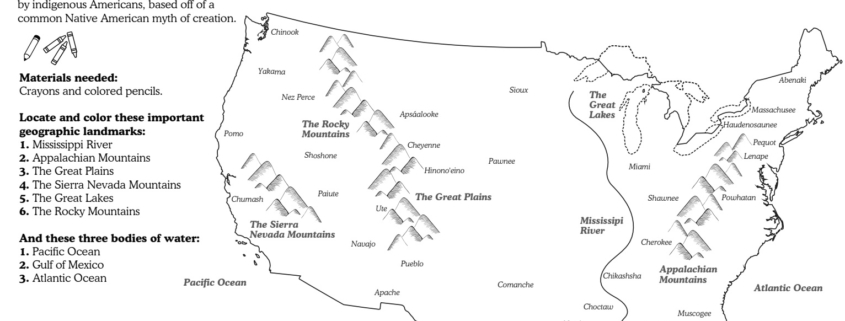
In the decades following the Emancipation Proclamation, Black Americans have continued to struggle for equal rights and treatment, even to this day. Native Americans were also subject to genocide and displacement as the colonies expanded to form what we now know as the United States after the signing of the Declaration of Independence.


Download Activity Sheet:


This week we are headed to the United States of America.

Before the arrival of Europeans, the land was inhabited by an estimated 50 million indigenous peoples, who lived in dozens of different tribes throughout the land. Today, the indigenous population is around 4.5 million, the result of disease and genocide committed by empires driven by their desire for conquest.

For this week’s activity you will color a map of the USA and identify key geographic landmarks, then find indigenous tribe names in a word search. This map of the United States shows the areas of land that were occupied by 34 indigenous peoples during the time before European settlers colonized North America, only a small portion of the tribes that used to live on this land. It is important to note that many indigenous populations have been known by different names, many of which are not what they refer to themselves as. For this reason you may not recognize all of the tribe names on this map. Try and see what you can learn about the names you don’t know.

Indigenous peoples – a term of self-identification that describes a person/people who have a long history living in and strong link with a specific territory, who have distinct cultures and societies, that pre-date colonial settlement

Genocide – the organized killing of a group of people, because of their race, religion, culture or nationality

Empire – one ruler who gathers and controls a group of territories or peoples

Conquest – to gain something (in this case, land), often with force and violence

Resources/Further Reading


Download Activity Sheet:


This week we’re taking a look at Canadian coins!

Canada’s long history means that there are a wide variety of coins used throughout the country, but for now we’re going to be looking at the most common ones: penny, nickel, dime, quarter, loonie and toonie. For the first activity you will use the different coin values to see what new coins they can add up to, then have fun coloring in three Canadian coins in the second activity.

Before you begin, you will need a pencil, eraser, and colored pencils or crayons.


Download Activity Sheet:


We’re traveling to the continent of North America for the next month.

First stop: Canada!
The second largest country in the world, Canada is known for its delicious maple syrup, beautiful natural landscape, hockey, and french and indigenous influences. There are 10 Canadian provinces: Alberta, British Columbia, Manitoba, New Brunswick, Newfoundland, Nova Scotia, Ontario, Prince Edward Island, Quebec and Saskatchewan, and three Canadian territories: Northwest Territories, Nunavut and Yukon.

For this week’s lesson you will color your own map of Canada, and find each province and territory. Before getting started you will need some crayons and pencils to color your map.


Download Activity Sheet:


Before you begin you will need crayons or colored pencils and a pencil.

First, explore the continents of North America. Take a look at the fourteen countries. See what countries you already know about and look for the names of new countries that you might just be learning about for the first time. Find their locations and when you feel ready, quiz yourself using the North America continents quiz.

When you are ready to move onto the next activity, take a look at the animals of North America map and give them some color to bring them to life!


Download Activity Sheet:


Note to parents

Some children will benefit from reading aloud the directions and making sure they know what each ocean is and how to color it accordingly. Of course, there can be slight variations on the colors if you do not have one of the shades of green or blue. The main idea is that children understand even though it looks like one big body of water, there are names to different oceans around the world.