Posts

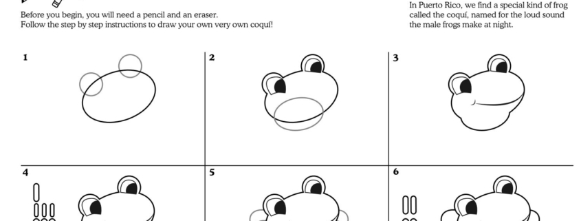
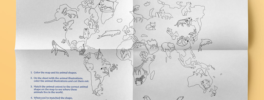
In today’s lesson, we will continue to apply your learning about maps, geography, and land and water forms as we explore the Caribbean Islands.

In lesson 6, we learned about some land and water forms that include a landform called an archipelago. An archipelago is a group of islands that are close together. That is why the islands in the Caribbean are called the Caribbean Archipelago. Did you know that there are over 7,000 islands in the Caribbean archipelago? There are 13 countries in the Caribbean and 12 territories! A territory is an extension of other countries. In the Caribbean, there are three main ecosystems such as forests, coastal areas, and wetlands full of wildlife, from birds to reptiles, and sea creatures!

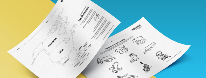
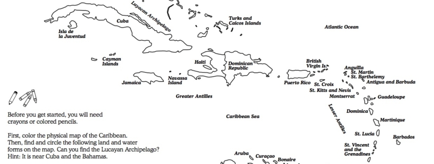
Today, you will color a map of the Caribbean islands and find some land and water forms in the region. Then, you can color some of our favorite animals of the Caribbean! Before you get started, you will need crayons or colored pencils to color the map.

First, color the physical map of the Caribbean. Find and circle the following water forms on the map:

Landforms

  • Lucayan Archipelago
  • Greater Antilles
  • Lesser Antilles

Water Forms

  • Straits of Florida
  • Gulf of Mexico
  • Atlantic Ocean
  • Caribbean Sea


In Puerto Rico, we find a special kind of frog called the coquí, pronounced ko-kee.

Coquís are named for the loud sound the male frogs make at night. Coquís are nocturnal, which means they are most active at night. During the day, they rest in the shade under logs and rocks. Coquís are carnivores, which is a fancy word for meat-eater. They like to eat other small critters like ants, crickets, moths, spiders, snails, smaller frogs, and even lizards!!

In today’s lesson, you will learn how to draw your own coquí! Before you begin, you will need a pencil, eraser, and colored pencils or crayons.

Coquís are one of the largest frog species found in Puerto Rico!

Coquís are a beloved symbol of Puerto Rico and the Taíno culture. Legends tell of a time when the island was inhabited by millions of coquís way before humans came to the island of Puerto Rico.

Many frog types have webbed feet but not coquís! Their scientific name (Eleutherodactylus) literally translates to “free toes.”

Coquís grow to be about one to two inches long. That’s the size of two quarters side by side. So tiny but so loud when they all sing at night in the jungles of El Yunque rainforest! Check out the clip to hear the sound the male coquís make at night!


Download Activity Sheet:


In Mexico, one of the most studied salamanders in the world are known as Axolotls.

Wild axolotls live in swampy areas of Lake Xochimilco and in the canals that flow into the southern edge of Mexico City.

Axolotls have also been known to have once lived in Lake Chalco, one of Mexico City’s five “great lakes”. This is one of the areas that the Aztecs settled. The Aztec called themselves Culhua-Mexica and they were a Nahuatl-speaking people who ruled a large empire in what we now call central and southern Mexico. The Axolotl name comes from the Nahuatl language and is pronounced Ax-oh-lot-ul. Atl means “water” and axolotl means “dog,” after the Xolotl, the canine Aztec deity.

In today’s lesson, we will learn how to draw your own Axolotl!

Before you begin, you will need a pencil, eraser, and colored pencils or crayons.

1) Did you know: Even though the Axolotl is commonly known as a “Mexican Walking Fish” it is not a fish at all. Axolotls are salamanders which is also a kind of amphibian. They are more like a cousin to a frog than they are to a fish.

2) Axolotls are carnivores known to eat worms, insect larvae, tiny shellfish known as crustaceans, and some fish.

3) Axolotls can live up to 10-15 years but are now considered to be a critically endangered species.

4) Did you know: Axolotls are neotenic salamanders, which means even as they grow older, Axolotls still look as if they are young.

5) Axolotls can regenerate (which is a fancy word to re-grow) the same limb up to 5 times!!


Download Activity Sheet:


Before you begin you will need crayons or colored pencils and a pencil.

First, explore the continents of North America. Take a look at the fourteen countries. See what countries you already know about and look for the names of new countries that you might just be learning about for the first time. Find their locations and when you feel ready, quiz yourself using the North America continents quiz.

When you are ready to move onto the next activity, take a look at the animals of North America map and give them some color to bring them to life!


Download Activity Sheet:


Note to parents

Some children will benefit from reading aloud the directions and making sure they know what each ocean is and how to color it accordingly. Of course, there can be slight variations on the colors if you do not have one of the shades of green or blue. The main idea is that children understand even though it looks like one big body of water, there are names to different oceans around the world.


Now, that you have learned about the different continents and the countries within them, let’s learn about the oceans of the world.

There are seven continents and five oceans on the planet. Before you get started, you will need five different colored crayons or colored pencils in various shades of blue and green as outlined in the instructions.

Color each ocean as follows:

  • Pacific Ocean: Teal or Turquoise
  • Atlantic Ocean: Dark Blue
  • Indian Ocean: Blue
  • Arctic Ocean: Light Blue
  • Southern Ocean: Light Green

Then, cut out some of the ocean animals provided (sheet 3) and add them to your map! You will need a glue stick and scissors for this part.


Download Activity Sheet:


Note to parents

Some children will benefit from reading aloud the directions and making sure they know what each ocean is and how to color it accordingly. Of course, there can be slight variations on the colors if you do not have one of the shades of green or blue. The main idea is that children understand even though it looks like one big body of water, there are names to different oceans around the world.


Let’s get to know where some of our favorite animals live in the world!

Before you begin, you will need markers or crayons, scissors, and glue.

1) Color the map and its animal shapes.
2) On the sheet with the animal illustrations, color the animal illustrations and cut them out.
3) Match the animal cut out to the correct animal shape on the map to see where these animals live in the world.
4) When you’ve matched the shape, glue the animal to its home!

Why do you think some animals live in only some parts of the world? What are some animals that live near water or in the water?


Download Activity Sheet:


Note to parents

Use this as a jumping-off point to discuss differences in weather or terrain. You could also talk about how animals need to live in certain climates to survive and live happy lives.