India isn’t just old, it’s ancient!

The Indian Subcontinent (which is the part of Asia where India, Pakistan and Bangladesh are located) has a rich ancient history, with archaeological records dating back to the Paleolithic time period, about 2.5 million years ago! Throughout the years of ancient history, India was inhabited by many ancient people, like the Indus Valley and Harappan civilizations. To this day you can still see artifacts and ruins from these ancient time periods, which have helped researchers learn more about what life was like back then. 

Let’s talk geography

India is one of the most biodiverse areas of land in the world, with a few major ecological features that make it distinct from any other part of the continent. One of these is the Deccan Traps, a massive volcanic province, covering 200,000 square miles made up of basalt lava flows, which began forming 66 million years ago! India is also home to the fertile Gangetic Plains and the Himalaya mountain range. 

Culturally wonderful 

India is home to a thriving movie industry, known as “Bollywood”, based in the capital city of Mumbai. One of the major characteristics of Bollywood films are the vibrant dance numbers that intersperse stories of romance, action, drama or comedy. Bollywood is strongly influenced by India’s national identity, and often depicts historical events from the country’s past. 
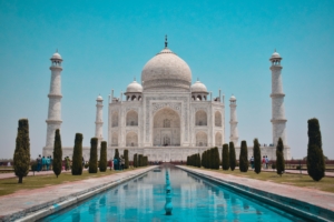
Take me to the Taj! 

Among the many iconic sites located in India, the Taj Mahal stands out as one of the most famous. This marble mausoleum, built by the Mughal Emperor Shah Jahan in a show of his love for his wife Mumtaz Mahal after her death, is also the tomb in which he was buried in the year 1658. To create the site, the emperor employed over 20,000 artisans and imported building materials from all over India and Asia. 


Traditional Chinese Opera, or Xiqu, has existed in China for over one thousand years. This type of musical theatre, accompanied by traditional Chinese instruments, features unique exaggerated makeup and masks of different colors.

Fun fact:
The color of a character’s mask gives clues to the audience about who they are what qualities they have.

For today’s activity, you will create your own Chinese Opera mask and color a beautiful opera scene. Before you begin, grab some crayons or colored pencils, a pair of scissors to cut out your mask when you are done, and some string to tie it on your face.


Download Activity Sheet:


This week we’re journeying to a new destination, Japan!

Japan is actually a string of islands in the Pacific ocean, located just off the east coast of Asia. There are five main islands: Hokkaido, Honshu, Shikoku, Kyushu and Okinawa, in addition to several smaller islands. The geography of Japan is made up of mostly mountains, with many volcanoes as well! The most well-known volcano is Mount Fuji, which is the highest peak in Japan at an elevation of 12,388 feet. Not too far from Mount Fuji is the capital city of Tokyo, home to over 36 million people, making it the largest metropolitan area in the world!

In today’s lesson, color your own map of Japan, then learn how to make your own origami fish! Origami is the art of paper folding, which has been practiced in Japan for over 300 years. Before you get started on these activities, you will need some crayons or pencils to color your map, and a square sheet of paper for your origami.

First, color your map, then find and circle the following:

The five main islands of Japan:
1) Hokkaido, 2) Honshu, 3) Shikoku, 4) Kyushu and 5) Okinawa

Then, find and circle:
1) the capital city of Tokyo, 2) Mount Fuji, 3) the Pacific Ocean

Next, grab a square sheet of paper, and follow the instructions on the worksheet to create your own origami fish.


Download Activity Sheet:


Journey through Puerto Rico with comedian Gina Brillon as she reads the Tiny Travelers Puerto Rico Treasure Quest book out loud. With so much to learn about Puerto Rico, from food to language, traditions, and more, you won’t want to miss out!


Pupusas are a favorite dish in El Salvador. Pupusas are a corn-based food stuffed with fillings like beans, cheese, and meat, and an edible flower called Loroco.  The loroco flower is native to Central America, and was called Quilite, which in the indigenous language means “herb you can eat.”

Pupusas are also enjoyed in neighboring Honduras where they are made with corn or rice flour. They are similar to arepas found in Venezuela and Colombia.  Pupusas originated from the native Pipil people in El Salvador and were first eaten by them almost 3,000 years ago!

In today’s lesson, you will learn how to make a cheese and loroco pupusa by collecting all the items to bring to the pupuseria, a special restaurant where they make pupusas. Have fun and enjoy today’s yummy activities!


Download Activity Sheet:


Today, let’s learn a little bit about traditional textiles and clothing in Panama.

Specifically: Mola, which comes from Panama’s San Blas Islands.
Molas are a type of woven textile made by the women of the Kuna people in Panama’s San Blas Islands. The word mola actually has two meanings: it is a Kuna word for clothing but it also refers to an important type of textile that features colorful panels sewn by the women of the native Kuna people. Traditionally, molas depicted the geometric shapes women painted on their bodies in ancient times. Molas have such importance for the Kuna and their traditional identity that even the school children have mola patterns as part of their school uniform!

As you begin today’s project, you can look online by searching the term “Kuna Molas” for images of the traditional clothing of the Kuna women to see examples of what molas look like. You will also notice other beautiful details that complete the outfits, including a patterned wrapped skirt (saburet), a red and yellow headscarf (musue), arm and leg beads (wini), a gold nose ring (olasu) and earrings, and the mola blouse (dulemor).

Today, color a pattern to make your own paper mola! You can use your mola as a piece of artwork on your wall, or give it as a gift to someone you love!

Fun fact:  Did you know? The tradition of molas as textiles go back to over 175 years!

Fun Fact: Did you know? The San Blas Islands are a group of islands in the archipelago de San Blas, located in the Northwest of Panama facing the Caribbean Sea. There are 378 islands within the San Blas archipelago. An archipelago is a group of islands surrounded by water.


Download Activity Sheet:


In today’s lesson, we will learn about the Ancient Maya number system

This color-by-number activity will bring to life the Temple of the Grand Jaguar at the Tikal ruins in Guatemala! The Ancient Maya used a counting system that was able to represent very large numbers by using only 3 symbols:

a dot to represent the number 1
a stick or bar to represent the number 5
and a shell symbol for zero, or completion

Check out the Mayan numbers chart and see if you can write your age in using Mayan numbers. See if you can also write out your favorite number in Mayan numbers too! Then, visit the ruins of Tikal, an ancient Maya City found in the rainforests of Guatemala near the border of Belize! The ancient Mayans lived in the southern part of Mexico and northern Central America, including Guatemala, Belize, Honduras, and El Salvador.


Download Activity Sheet:


In today’s lesson, you will make a flag banner for the countries in Central America.

The three stripes (blue, white, blue) are common in many Central American flags. For example, in the Salvadoran flag, the royal blue shade was chosen to represent the oceans and sky of Central America. The white represents unity and peace. In Guatemala’s flag, the blue stripes represent the two oceans on each side of the country, the Atlantic and Pacific oceans.
Today, let’s bring the flags of Central America to life! Using the examples provided, create, and color your own flags. When you’re done, cut them out and string together to form your own flag banner!

Instructions:

  1. Color the country flags to match the flag examples. Then, cut out each flag.
  2. Decide where you will put your flag garland and cut a piece of yarn for the size that you want.
  3. Cut the fold over the top area of the flag and hook it over the piece of yarn.
  4. Tape the folded part to the back of the flag.
  5. Add each flag to your banner string.

If you need more string, cut more yarn and tie a knot to tie the string together.


In today’s lesson, we will explore the geography of Central America.

With our coloring sheet, see if you can color and find some important land and water forms in Central America. Also, with a second fun coloring activity, get to know the countries and animals that make up this beautiful region! Before you begin, check out our Lesson Guide download for an overview of today’s lesson from a teacher!


In today’s lesson, you will learn how to make a simple yet very delicious drink from the Caribbean islands, Morir Soñando.

This means to “die dreaming,” because this drink is so yummy! The origins of this drink are believed to be from the Dominican Republic, but Puerto Ricans, Cubans, and many more have their own versions to this sweet delight!

Today, learn how to make an all-natural version of this Caribbean classic with guidance from our friend Chef Issa from Issa’s Edible Adventures! While most recipes use evaporated milk or condensed milk and sugar, this recipe offers coconut milk, or nut milk version. Instead of sugar, this recipe uses dates! Have fun making this dreamy orange drink and enjoy it with your loved ones!