Learn About Lebanon: Nature!

Welcome to Lebanon, Tiny Travelers!

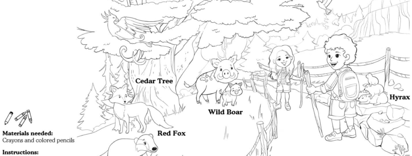
This week, we have a chance to add a splash of color to Lebanon’s Cedar Nature Reserve!

The largest of Lebanon’s nature reserves, Al-Shouf Cedar Nature Reserve stretches from Dahr Al-Baidar in the north to Niha Mountain in the south. The reserve hosts 32 species of wild mammals, of which 9 are considered to be rare at the international levels.

Cedar trees in Lebanon are special; we know they were used to build temples and ships long ago. In fact, some cedar trees are more than 3,000 years old WOW!which is why they symbolize resilience, immortality and strength. At the Cedar Nature Reserve, animals roam free. For this week’s lesson, you will color a scene from the Cedar Nature Reserve, including the following animals:

Wild boar

Red fox

Badger

Hyrax

And of course, a Cedar Tree. 

You might even hear the sounds of the reserve as you color this lovely scene from Lebanon and bring it to life!


Download Activity Sheet:


Learn about France: Architecture

Welcome to France, Tiny Travelers!

This week, we’re going to bring Notre Dame Cathedral to life! It is located in the capital of France, Paris, on a small island in the River Seine. 

There are lots of fascinating facts about this beautiful landmark to learn. The name “Notre Dame de Paris” literally means “Our Lady of Paris,” and the cathedral is famous for the story of the hunchback who once lived there and rang its bell! Have you heard of it? The hunchback must have been busy, because there are ten bells at Notre Dame, and they all have names — most of them come from Catholic saints, like Anne-Geneviève.

Notre Dame was built over 700 years ago, during the Middle Ages! It’s a great example of Gothic architecture, which you might recognize from dramatic features like stained glass windows (the cathedral has three, known as the rose windows), pointed arches, and elaborate decoration. 

For this week’s lesson let’s color a lively scene from the Notre Dame Cathedral in Paris, including the following elements:  

Accordion

South tower (right)

North tower (left)

River Seine

Beret


You might even feel a little gust of fall wind coming through as you color this lovely scene!


Download Activity Sheet:


Learn About Haiti: Culture!

Welcome to Haiti, Tiny Travelers!

This week, we have a chance to add a splash of color to Haiti’s Rara festival! This carnival, which is full of lively street processions, embodies the musical spirit and vibrant culture of Haiti.

There are many elements that make up the ritualistic musical reunion that is Rara: woodwind instruments called vaksen or banbou, the metal-made trumpet kòne, different types of drums, maracas, grags (also called güiras), flutes, and much more! Streets are enveloped in song and melodies as Rara bands, some featuring only women, make their way through neighborhoods (sometimes for miles!), while parade-goers and fans partake by way of singing and dancing.

The vaksin or banbou are especially popular during Rara — they are long hollow tubes that serve as horns, and, depending on their size, create a different sound! Their unique sound is essentially synonymous to Rara. The tanbou, a barrel drum stemming from Haiti, which is carried cross-body, is also very much present, and it is said that the older the drum…the better the sound!

For this week’s lesson you will color a scene from the Rara carnaval, including the following elements:

Vaksin
Kòne
Tanbou
Chapo pay
Zwazo

You might even feel the music coming through as you color this lovely scene from the parade!


Download Activity Sheet:


Welcome to Egypt, Tiny Travelers!

This week we we will continue to apply all of your learning about maps, geography, and land and water forms as we explore Egypt. Located in northeast Africa, Egypt has a desert climate of extreme hot during the summer and cold during the winter. Because Egypt only receives about one inch of rainfall each year, the Nile River is an important source of water, with annual floods that allow for crops to grow. These floods were crucial for the ancient civilizations that inhabited Egypt, which is why some of the most iconic historic sites are located near the Nile, such as the great Pyramids of Giza, the Sphinx, and the Valley of Kings, not to mention the capital city of Cairo. 

For this week’s lesson you will color a map of Egypt, then find and circle important geographic landmarks and cultural sites:

  1. The Nile River
  2. The Red Sea
  3. The Western Desert
  4. The Sinai Peninsula
  5. The Mediterranean Sea
  1. The capital city of Cairo 
  2. The Pyramids of Giza
  3. The Valley of Kings

Download Activity Sheet:


Independence Day, also called the Fourth of July, is a historic holiday in the United States.

It celebrates the day in the year 1776 when the Declaration of Independence was signed by the Continental Congress, declaring the independence of the American colonies from Great Britain.

It is important to remember that while the white colonists gained autonomy from the British empire, the Declaration of Independence did not grant freedom to all of the people who inhabited the land known as the United States. African slaves, who had been forcefully brought to the United States as early as 1619, were not given legal freedom until the Emancipation Proclamation was signed in 1863, almost one hundred years later.

In the decades following the Emancipation Proclamation, Black Americans have continued to struggle for equal rights and treatment, even to this day. Native Americans were also subject to genocide and displacement as the colonies expanded to form what we now know as the United States after the signing of the Declaration of Independence.


Download Activity Sheet:


This week we are headed to the United States of America.

Before the arrival of Europeans, the land was inhabited by an estimated 50 million indigenous peoples, who lived in dozens of different tribes throughout the land. Today, the indigenous population is around 4.5 million, the result of disease and genocide committed by empires driven by their desire for conquest.

For this week’s activity you will color a map of the USA and identify key geographic landmarks, then find indigenous tribe names in a word search. This map of the United States shows the areas of land that were occupied by 34 indigenous peoples during the time before European settlers colonized North America, only a small portion of the tribes that used to live on this land. It is important to note that many indigenous populations have been known by different names, many of which are not what they refer to themselves as. For this reason you may not recognize all of the tribe names on this map. Try and see what you can learn about the names you don’t know.

Indigenous peoples – a term of self-identification that describes a person/people who have a long history living in and strong link with a specific territory, who have distinct cultures and societies, that pre-date colonial settlement

Genocide – the organized killing of a group of people, because of their race, religion, culture or nationality

Empire – one ruler who gathers and controls a group of territories or peoples

Conquest – to gain something (in this case, land), often with force and violence

Resources/Further Reading


Download Activity Sheet:


This week we’re taking a look at Canadian coins!

Canada’s long history means that there are a wide variety of coins used throughout the country, but for now we’re going to be looking at the most common ones: penny, nickel, dime, quarter, loonie and toonie. For the first activity you will use the different coin values to see what new coins they can add up to, then have fun coloring in three Canadian coins in the second activity.

Before you begin, you will need a pencil, eraser, and colored pencils or crayons.


Download Activity Sheet:


We’re traveling to the continent of North America for the next month.

First stop: Canada!
The second largest country in the world, Canada is known for its delicious maple syrup, beautiful natural landscape, hockey, and french and indigenous influences. There are 10 Canadian provinces: Alberta, British Columbia, Manitoba, New Brunswick, Newfoundland, Nova Scotia, Ontario, Prince Edward Island, Quebec and Saskatchewan, and three Canadian territories: Northwest Territories, Nunavut and Yukon.

For this week’s lesson you will color your own map of Canada, and find each province and territory. Before getting started you will need some crayons and pencils to color your map.


Download Activity Sheet:


Sanskrit is the world’s oldest language and the holy language of the Hindu, Buddhist and Jain religions.

It is one of twenty two languages spoken in India today, and while it is not the most commonly used, it is the foundation of almost all languages of Indian origin. Sanskrit grammar is very complex with eight different grammatical cases (English only has three), sixteen vowel sounds and three different ways that numbers can be grammatically written.

In today’s lesson you will learn to write five words in Sanskrit; Together, speak, body, like and om- which is the sound that people make when meditating. Grab a pencil and eraser and try it out!


Download Activity Sheet:


Namaste, Tiny Travelers! This week we’re learning about yoga.

Yoga, which means ‘union’ in Sanskrit, is a spiritual and physical practice originating thousands of years ago in ancient India. It involves breathing, exercise and meditation, which aim to improve health and happiness. During a yoga session a person will move through a sequence of postures, or, ‘asanas.’ Since its creation, yoga has become popular all over the world and developed many different schools of practice. In this week’s lesson you will learn six beginner yoga poses.

Color in the poster, then see if you can do each pose one after the other!


Download Activity Sheet: